 Webcams
 Live info
 Ski passes
 Useful information
 Retour
randonnee
Retour
randonnee
Walking route -Tête de Lindaret - Pointe de Chésery from Bassachaux
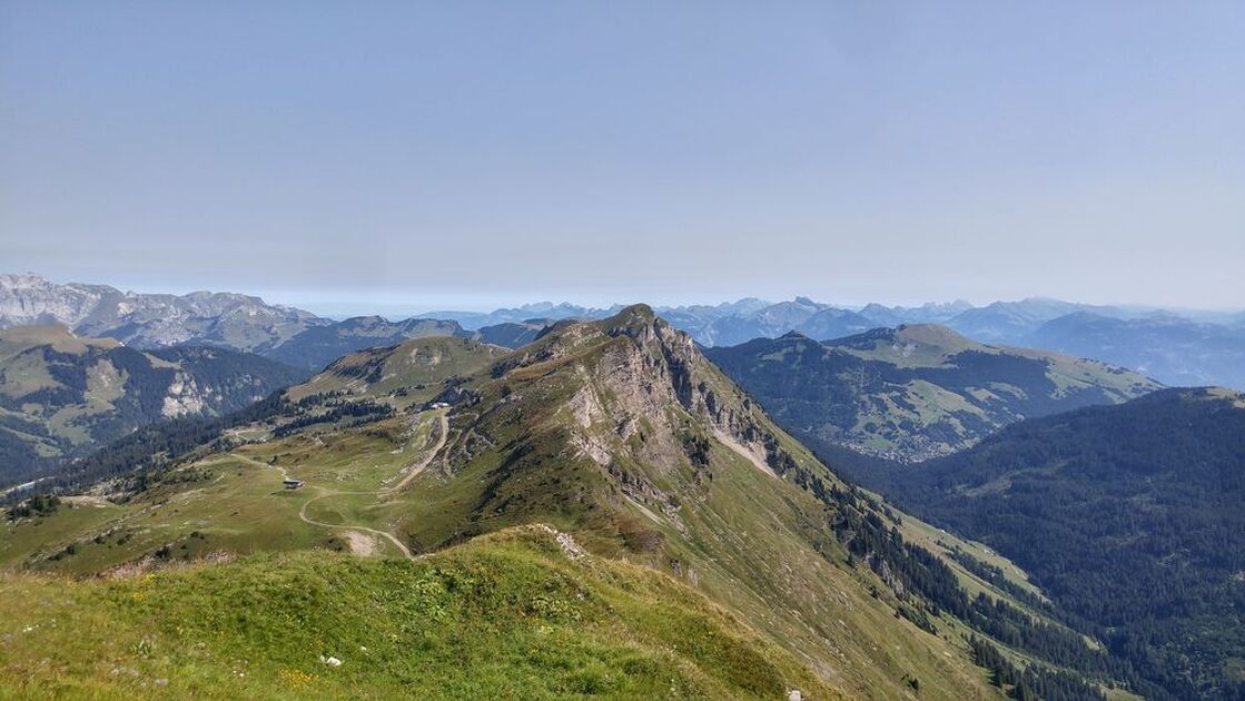
A beautiful hike from the Col de Bassachaux. Panoramic views of the Portes du Soleil area, Mont de Grange, Mont Blanc, Dents du Midi, Lake Montriond...
Description
The tête de Lindaret is an easy hike, but with a good climb all the same.
After leaving the Col de Bassachaux, you will first reach the tête de Lindaret at an altitude of 1,950m, where you can enjoy a 360° view.
You will then reach the Pointe de Chésery, which marks the border with our Swiss neighbours. At 2251m, you can admire the view of the Swiss mountains and surrounding valleys.
If you're passing through Rochassons, you can try the Fantasticable, which leaves from the top of the chairlift. Comfortably installed in a harness, you can fly over the hamlet of Plaine-Dranse at almost 100 km/h and up to 240 m high.
Additional information
Whichever walk you choose, we recommend that you :
- Wear appropriate footwear and always take with you: warm clothing, preferably waterproof, plenty of water, sunglasses, sun cream and a small first-aid kit.
- Do not set off alone.
- Inform someone living in the valley of your plans.
- Do not change the planned itinerary indiscriminately. But do not hesitate to shorten it if necessary.
- Carry a map and even a torch.
- Check the weather forecast before setting off.
- In the event of a thunderstorm, move away from ridges, passes and summits as soon as possible and never take shelter under an isolated tree.
-
Minimum age : 8 years
Animals
Pets allowed : Yes
Dogs must be kept on a leash due to the presence of herds.
Prices
Free entry but transport fee applies.
Route
-
 Distance
6.5km
Distance
6.5km
-
 Type of itinerary
Loop
Type of itinerary
Loop
-
 Elevation gain
525m
Elevation gain
525m
-
 Negative elevation
525m
Negative elevation
525m
-
 Daily duration
02h50
Daily duration
02h50
-
 Marked itinerary
Yes
Marked itinerary
Yes
-
 Details about signage
Departmental markings called P.D.I.P.R. on beige metal panels with green lettering.
Details about signage
Departmental markings called P.D.I.P.R. on beige metal panels with green lettering.
-
 Types of terrain
Stone,
Ground,
Not suitable for strollers
Types of terrain
Stone,
Ground,
Not suitable for strollers
-
 Maximum altitude
2250m
Maximum altitude
2250m
Opening period
From 01/06 to 31/10.
Adaptive tourism
-
 Not accessible in a wheelchair
Environments
-
Lake view
-
Mountain view
-
Mountain location
-
Panoramic view
Location
Access (by car): From Châtel, drive to the Col de Bassachaux. At the Col, park in the parking lot.
Access (bus): Bus line 1, terminus Pierre Longue (July and August) then take the Pierre Longue chairlift to Plaine Dranse then take the road to the trailhead at Col de Bassachaux.


-
Distance
6.5km
-
Daily duration
02h50
-
Elevation gain
525m
-
Negative elevation
525m